The war in Ukraine threatens the global food supply chain. Russia and Ukraine are two of the largest grain producers and suppliers in the world, with over half of the grain bought by the World Food Programme coming from the Ukraine. This has the UN, global aid organizations and government officials warning of an increase in world hunger.
Facing increased food insecurity in Morocco
June 26, 2022
Many developing nations such as Morocco already face food insecurity due to unseasonably dry and hot weather in January and February of 2022. The country’s common wheat, durum wheat and barley production are being driven to record lows, about 15% below the five-year average. The USDA expects below-average yields to result in 2.25 million tonnes of wheat and 600,000 tonnes barley, 70% and 78% lower than 2021-22, respectively.
While Morocco produces about two thirds of the wheat its population consumes, the country typically relies on Ukraine exports for the balance. Supply chain disruptions, combined with climate change, does not bode well for the North African nation whose residents rely heavily on wheat and other grains in their diet. More information about growing patterns and crop progress is needed to improve yields and reduce risk. One of the best ways to get this information is by examining large-scale geospatial images and visualizing overlays of annual earth observation data. EarthDaily Analytics has the means, and modality, to produce these images through EarthMosaics™, a geospatial imaging service now available in Beta.
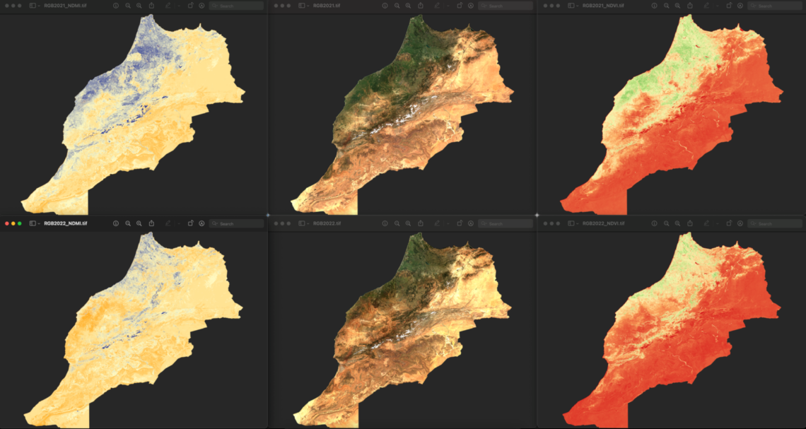
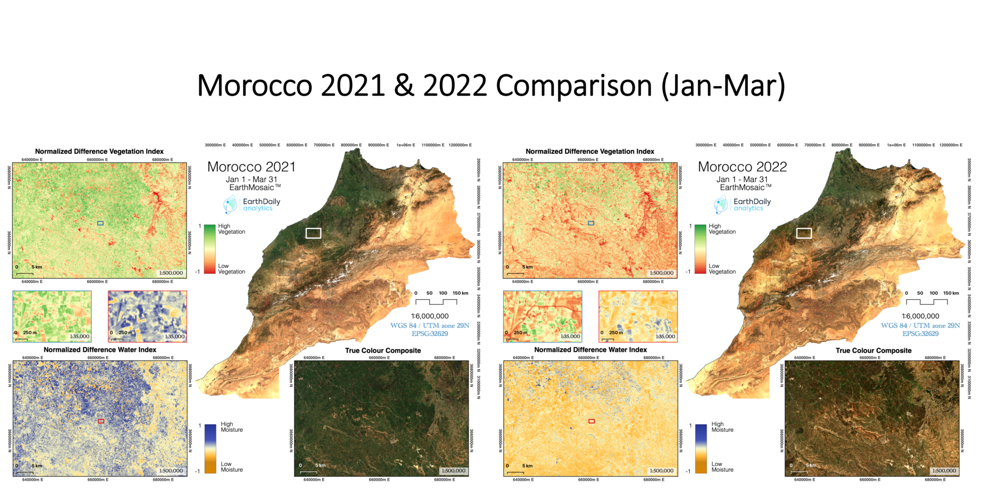
Analyzing Morocco’s growth patterns and crop progress
EarthDaily Analytics is a Vancouver-based company that develops world-first technologies in earth observation, geoanalytics and data imagery services. The company’s EarthMosaics service reduces the cost, time and complexity associated with producing high quality, cloud-free mosaics so that the private sector and communities gain faster, easier access to analytics-ready satellite data for more informed, large-area planning.
“The big issue with massive amounts of ‘big data’ is finding practical ways to extract value and deliver it to end users at scale. EarthMosaics provides the necessary evidence to amass a significant call to action to address the expected food shortage in coming months.” – Chris Rampersad, VP, Engineering at EarthDaily Analytics
Analyzing Morocco’s changing terrain through EarthMosaics means the country can actively monitor crop progress using high quality cloud-free ready mosaics, fused together from hundreds to tens of thousands of input images. Land cover changes provide a vital mapping input into ecosystem, climate, and carbon sequestration models. As seen in the year over year images of Morocco, the reduction in vegetation and water is very clear. With this geospatial imagery, the country can gain better visibility into long-term trends, monitor change, and take guided, strategic actions to fix and secure their food supply chain. Crop progress reports are created fortnightly.
The EarthMosaics software was developed as part of the Digital Supercluster’s Satellite-based Environmental Analytics project, in collaboration with partners such as Microsoft, BC Parks Foundation, the University of Victoria, Hatfield Consultants, BGC Engineering, Mitacs and Environment and Climate Change Canada.
“EarthDaily Analytics has been able to market, and sell, the technology developed through its Digital Supercluster projects,” says Rampersad. “In addition to agricultural applications there are other urgent climate-based concerns like forest fires that can benefit from large-scale images. The Supercluster investment not only enabled us to advance our technology but played a key role in opening our collaborative network and connecting us with end-users.”
Creating the Ukraine Farmers Coalition
In addition to helping at-risk developing nations such as Morocco, EarthDaily is also helping Ukraine farmers by mobilizing a coalition of 100 diverse farmers, industry, NGO and governmental partners to provide in-kind seed and crop inputs, satellite-derived prescriptions and in-season monitoring. With technology that provides analysis-rich, historical snapshots of their prized soil, Ukraine farmers can select the right seed and fertilizer from the safety of a laptop. Less time in open fields means less exposure to Russian land mines, missiles or snipers.
Developing state-of-the-art satellite imagery processing
In addition to EarthMosaics, EarthDaily Analytics also developed and refined the EarthPipline, the world’s first raw satellite imagery processing and calibration service offering, as part of another Digital Supercluster project known as Earth Data Store. This technology is currently used in a project for the Canadian Space Agency.
“The agility and quality of the software developed, combined with the processing expertise grown through the Earth Data Store project has set our organization apart. We have tackled the normalization problems of data, particularly with data generated from multiple sensors, which can consume up to 80 per cent of the analysis preparation. EarthDaily is excited to offer these time savings to companies that deliver big data/geospatial analytics products and information services – a global market we estimate to be worth $10B.”
A Global Endeavour
EarthDaily Analytics is not only changing how people view the earth, but also how people access and gain insight from that data. In 2023, EarthDaily Analytics will launch EarthDaily, the world’s first earth observation system designed from the ground-up to produce scientific-quality imagery of the entire earth every day.